 Patch Fort Lee, NJ --
Heavy rain, flash flooding and gusty winds are predicted Friday as Tropical Storm Andrea moves up the east coast and toward New Jersey.
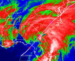
By late Thursday night, the storm had made landfall in Florida and began its inland trek up the eastern seaboard. The storm was packing 45 m.p.h. sustained winds and moving briskly to the northeast at 13 m.p.h., according to the National Hurricane Center in Miami.
In New Jersey, Jersey Shore residents were expected to experience the highest sustained wind speeds – predicted to be around 40 m.p.h. – while the entire state would likely see heavy rain and the potential for flash flooding. Tidal flooding was expected to be relatively minimal and limited to the Friday night high tide cycle, however, according to a forecast released by the National Weather Service's office in Mount Holly.
A flash flood watch remains in effect until 8 a.m. Saturday morning, along with a small craft advisory and a gale warning for offshore waters. Seas were expected to build to 5 to 8 feet offshore by Friday night.
The NWS forecast said the storm will likely be offshore by the time it makes it to New Jersey, meaning the strongest winds would be located over the ocean.
But no one will escape the rain.
"Widespread rainfall amounts of two to four inches are expected, starting late [Thursday] night, and ending on Saturday morning," the forecast said. "Rainfall amounts in this range will produce flash flooding, as well as potential river flooding."
It appears New Jerseyans will escape one major threat that Florida residents dealt with Thursday.
"Tornadoes have been occurring with the system down in Florida, but are not expected to be a threat when Andrea arrives in our region," the forecast said. Reported by Patch 9 hours ago.