 Patch Holly Springs-Hickory Flat, GA --
The threat of winter weather for Holly Springs is looming again.
According to the National Weather Service
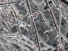
 , there is a "chance" of freezing rain overnight Thursday and "likely" for Friday before 4 p.m. Also, winds could reach 15 mph.
The low Thursday night is forecast to be about 28 degrees. An Arctic air mass and moisture moving into the area is blamed.
The NWS hazardous weather outlook reads in part:
THIS HAZARDOUS WEATHER OUTLOOK IS FOR NORTH AND CENTRAL GEORGIA. ... THURSDAY THROUGH TUESDAY... AN ARCTIC AIRMASS WILL BE MOVING INTO THE EASTERN HALF OF THE UNITED STATES ON THURSDAY SETTING UP A COLD AIR WEDGE ACROSS NORTH AND CENTRAL GEORGIA. AT THE SAME TIME MOISTURE FROM THE WEST AND SOUTHWEST IS EXPECTED TO RISE UP AND OVER THE COLD AIR AT THE SURFACE. THE COMBINATION OF THESE INGREDIENTS WILL SET THE STAGE FOR POSSIBLE FREEZING RAIN AND SLEET OVERNIGHT THURSDAY NIGHT THROUGH FRIDAY MORNING.
The wintry threat should end by the weekend. Forecasts call for sunny weather and a high near 45 and a low around 28 on Saturday. Partly cloudy skies will return on Sunday with a high around 46.
Holly Springs-Hickory Flat Patch will have continued updates on the weather situation.
**Keep up with Holly Springs-Hickory Flat Patch news by subscribing to our newsletters
and following us on Twitter and Facebook! ** Reported by Patch 4 days ago.